THE FIRST AI-POWERED PLATFORM FOR THE WATERWAY

Know where your
vessels are.

AIS tracking, smart convoys, fuel management, maintenance and artificial intelligence in one platform. No hardware. No installations. Operational in 5 minutes.

No hardware needed
Predictive AI
Operational in 5 minutes
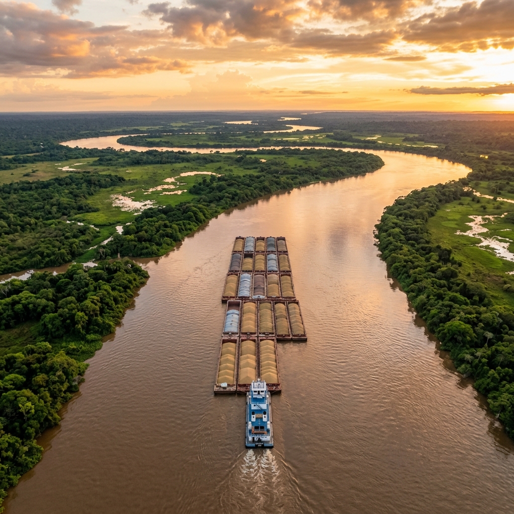
Paraná-Paraguay Waterway aerial view
PARANÁ — PARAGUAY WATERWAY

The Paraná-Paraguay Waterway:
the river highway of South America.

3,442 km of strategic navigable route connecting five countries and moving over 100 million tons per year. Soy, minerals, fuels, containers — everything flows through the Paraná-Paraguay system. FluviaFleet is the first AI-powered platform designed exclusively for this route.

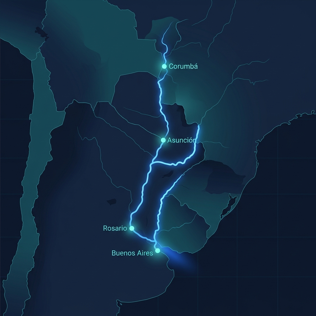
From the iron mines of Corumbá to the deepwater ports of Rosario and Buenos Aires, the Paraná-Paraguay is the logistics corridor sustaining the Mercosur economy. However, 80% of fleets still operate with paper spreadsheets and VHF radio.
Argentina
Paraguay
Brasil
Uruguay
Bolivia
Paraná-Paraguay Waterway map

Strategic ports
of the Paraná-Paraguay

The waterway crosses the productive heart of Mercosur. Each port is a critical node in the export chain of grains, minerals, and fuels that drives the regional economy.

Corumbá / Ladário
Brasil
Km 2.770
760 km · ~3-4 days
Concepción
Paraguay
Km 2.010
380 km · ~2 days
Asunción
Paraguay
Km 1.630
430 km · ~2-3 days
Barranqueras
Argentina
Km 1.200
620 km · ~3 days
Santa Fe
Argentina
Km 580
160 km · ~1 day
Rosario (Hub Sojero)
Argentina
Km 420
180 km · ~1 day
Buenos Aires
Argentina
Km 240
240 km · ~1-2 days
New Palmira
Uruguay
Km 0
0
NAVIGABLE KILOMETERS
0
MILLION TONS/YEAR
0
CONNECTED COUNTRIES
0
ACTIVE PORTS

CARGOS TRANSITING THE PARANÁ-PARAGUAY

Soy & Cereals
Iron Ore
Fuels
Containers
Wood & Cellulose
Clinker & Cement
Chemicals
Fertilizers
Vehicles

Why is the Paraná-Paraguay
so strategic?

It is the logistics backbone of Mercosur. Without it, commodity transport costs would multiply 5x compared to land freight.

5x cheaper than trucks

River transport via the Paraná-Paraguay reduces logistics costs by up to 80% compared to road transport. A 16-barge formation equals 960 trucks.

Minimal carbon footprint

River transport emits 5 times less CO₂ per ton/km than trucks. Companies operating on the waterway lead the transition to sustainable logistics.

Unstoppable growth

Traffic on the Paraná-Paraguay grows 8% annually. Investments in dredging, signaling, and private terminals exceed USD 2.000M planned until 2030.

The Paraná-Paraguay needed
a platform at its level

FluviaFleet digitalizes every kilometer of the waterway. AI satellite tracking, 40,000-ton convoy management, fuel control saving millions, and a smart Copilot knowing every river stretch — from Corumbá to New Palmira.

Request a Personalized Demo

No commitment · Response in 24hrs · Support in English & Spanish

Four steps to
digitalize your fleet.

No complex installations. No expensive hardware. Start operating your fleet smartly in minutes.

01

Load your fleet in minutes

Import your barges and tugboats. The system detects existing AIS data. No hardware. No field technicians.

02

The river talks, you listen

Real-time water levels, draft alerts, weather conditions. The Copilot warns you before problems happen.

03

Convoys built with data, not calls

Automatic draft validation based on river level. Optimal formation suggested by AI. No more endless phone calls.

04

Your operation, in real numbers

Automatic reports on fuel, cost per voyage, efficiency per sector. Fully exportable. Fully auditable.

COMPLETE ECOSYSTEM

Everything your fleet
needs in one place.

12 integrated modules covering every aspect of fluvial operations.

Fleet Management

Total asset control and operational status

AIS Tracking

Real-time satellite positioning

Convoy Builder

Smart convoy assembly with draft validation

Maintenance

Preventive and corrective maintenance

Fuel Analytics

Bunker control and sector efficiency

Documents & Logbook

Operational records with photos and audit

Crew Management

Crews, certifications, and watch schedules

Port Operations

Port operations management

Voyage Planning

Voyage planning and dispatch

FluviaFleet AI

Smart copilot for operations

Reports & Analytics

KPIs, trends and exportable reports

Alerts & Incidents

Automatic alerts and incident tracking

The first smart copilot
for fluvial operations.

Ask in plain language. We answer with your real operational data.

Which convoy has the highest consumption this week?
Convoy ASU-ROS-03 averages 12.4 kL/day, 23% above average. Probable causes: adverse current in Corrientes-Resistencia sector and cruising speed above optimal.
Which vessels need urgent maintenance?
3 vessels with active alerts:
· Tugboat Guaraní II — main engine, due in 3 days
· Barge PY-0047 — hull inspection, 5 days overdue
· Barge PY-0089 — navigation certificate, due this week
Show me vessels arriving at Rosario this week.
4 vessels with confirmed Rosario ETA:
· ASU-Convoy-03: Wednesday 2pm (no alerts)
· Tugboat Delta I: Thursday 9am (4hr delay, low water)
· Barge AR-112: Friday 4pm
· Convoy PY-Norte-07: Saturday 11am
What are the biggest operational costs this month?
Fuel accounts for 67% of total cost this month. Asunción-Corrientes sector has highest relative consumption. Recommendation: review cruising speed on that stretch.
THE PLATFORM

Designed for
the Waterway.

3,442
KM OF WATERWAY COVERED
12
INTEGRATED MODULES
5
COUNTRIES CONNECTED
<5 min
INITIAL SETUP

Power for fleets
of all sizes.

Starter

Up to 5 vessels

$149 /month
  • AIS Tracking
  • Digital Logbook
  • Fuel Control
  • Preventive Maintenance
  • Convoy Builder
  • AI Copilot
Request Demo

Enterprise

Unlimited vessels

Contact Sales
  • Everything in Professional
  • API Integrations
  • SLA 99.9%
  • 24/7 Dedicated Support
  • Custom Onboarding
Contact Sales

Calculate how much
FluviaFleet can save you.

Enter your fleet data and see the projected impact in real time. No registration required.

$0
Estimated annual savings
$149
Monthly FluviaFleet cost
0
Estimated ROI
$0
Year 1 net savings

These figures are projections based on an estimated 18% fuel consumption reduction. For a personalized analysis with your real operations:

A barge sitting idle for one day due to lack of information costs more than a month of FluviaFleet.

CASE STUDY

Real results with
real operators.

PILOT PROGRAM — PARAGUAY-PARANÁ WATERWAY
1. SITUATION

Initial Scenario

Mid-size operator with 12 barges and 3 tugboats. 100% manual management with Excel, VHF radio and paper forms.

2. CHALLENGE

Key Problems

No real-time position visibility. Rising fuel costs without data to diagnose cause. 3 incidents without sufficient documentation.

3. IMPLEMENTATION

Quick Deployment

5-day onboarding. Integration with existing AIS data. Remote team training. No additional hardware.

4. RESULT

Measurable Impact

Full fleet visibility. Projected 18% fuel reduction. Digital logbook eliminated 3 daily follow-up calls per vessel.

Based on pilot program data. Results may vary. Full case available under NDA.

Integrated with
world-class technology.

Google Maps Platform
AIS Stream
Open Meteo
Supabase
Stripe
Firebase Cloud Messaging

Cloud infrastructure with data encrypted in transit and at rest.

Answers to what
everyone asks.

No. FluviaFleet is 100% cloud-based. We use your existing AIS data and standard GPS. No physical installation or field technicians required. You're operational in minutes.
FluviaFleet requires internet to sync real-time data. However, AIS data is captured continuously and syncs when connection is restored. The mobile app works offline for logbook and incident recording, syncing when back in coverage.
Your data is 100% private, encrypted in transit and at rest. Each company has an isolated environment (multi-tenancy). No other user or competitor can see your information. We comply with LGPD (Brazil) and GDPR standards.
No. Your vessel positions are only visible to authorized users in your company. Public AIS data (already visible on platforms like MarineTraffic) doesn't change, but your internal operational data is 100% private.
Full onboarding takes 1-5 days depending on fleet size. For small fleets (up to 10 vessels), you can be operational the same day. Includes remote training for your team.
You can cancel anytime with no penalties. Your data remains available for export for 30 days after cancellation. No minimum commitment contracts.
FluviaFleet is designed for the Paraguay-Paraná Waterway and covers operations in Argentina, Paraguay, Brazil, Uruguay and Bolivia. The platform is available in Spanish and English.
Starter: email support during business hours. Professional: priority support with under 4-hour response. Enterprise: dedicated 24/7 support with assigned account manager and guaranteed SLA.
ABOUT US

Who we are

FluviaFleet was born from a real frustration: managing fluvial operations on the Paraguay-Paraná Waterway with last-century tools. Paper forms, VHF radio, and endless phone calls just to know where a barge is. We built the first AI-powered platform designed exclusively for this route — because we know it, because we navigate it, and because it deserves technology that matches its scale.

Our mission: digitalize every kilometer of the Paraguay-Paraná Waterway.
Asunción, Paraguay · Regional operations in 5 countries
info@fluviafleet.com

Your competition still uses
VHF radio and spreadsheets.

While other operators manage their fleet with phone calls, Excel and paper, you can know where every barge is, how much fuel it burned and what needs maintenance — in real time. The Waterway doesn't wait. Your fleet shouldn't either.

CONTACT

Let's talk about
your fleet.

Want to see FluviaFleet with your data? Fill out the form or reach out directly.

WhatsApp

Quick response during business hours

+595 994 207 248

Email

Response within 24 hours

info@fluviafleet.com

Schedule Demo

Book a personalized walkthrough

Schedule a call